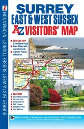
Surrey, East and West Sussex A-Z Visitors\' Map: (New 26th edition)
This full colour visitors\' map of Surrey, East Sussex & West Sussex features road mapping that covers an area extending to:*The south coast from Portsmouth to Hastings*Ashford (Kent) and Faversham to the east*Reading, central London, Gravesend and Sheerness to the north*Fareham and Basingstoke to the west. Map detail is shown at a clear 2.5 miles to 1 inch scale (1.6 kms to 1 cm) and includes the following features:*Motorways, service areas, primary routes and destinations, A & B roads, tolls, mileages, gradients 1:5 and steeper and county boundaries.*Full major road junction detail.*Selected safety camera locations with their maximum speed limits and fuel stations.*Selected places of interest, tourist information centres, caravan and camping sites and golf courses.*Areas of Outstanding Natural Beauty and the boundary to the UK\'s newest National Park, the South Downs National Park, are also shown. There are 2 separate index panels adjacent to the mapping:*An index to cities, towns, villages, hamlets and locations*A comprehensive places of interest index with the corresponding map symbol shown alongside each entry for easy identification.
£5.95
Similar Deals

Skratch Labs The Feed Zone Cookbook
£21.99
From Tredz

The Northern Caminos Book
£16.95
From Jackson Sport

Canoe Camping Book
£16.99
From Jackson Sport

Wicklow Climbing Guide Book
£17.50
From Jackson Sport

Northern Ireland - A Wallking Guide Book
£13.99
From Jackson Sport

7 + 8 Fontainbleau Book
£30.00
From Jackson Sport

Sit-On-Top Kayak Book
£9.99
From Jackson Sport

Dalkey Quarry Book
£20.00
From Jackson Sport

